
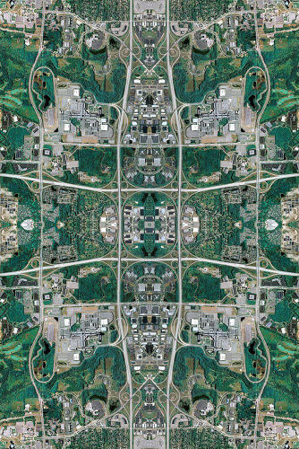

David Thomas Smith’s Anthropocene series combines Google Maps of human-influenced landscapes with the intricate designs of Persian rugs.
Drawing from the symmetrical patterns of traditional Persian carpets, Dublin-based artist David Thomas Smith’s Anthropocene series reimagines landscapes from Google Maps. Each image is a digital “rug” fashioned from thousands of satellite aerial views. Among them are photographs of the Beijing International Airport, the Mall of America, and Three-Mile Island.
The work is currently on show at Dublin’s Copper House Gallery. According to the gallery site, Smith created the images “using a unique and groundbreaking technique. Each image is composited from thousands and thousands of thumbnails extracted as screen grabs from Google Maps, which are then reconstructed piece by piece using Photoshop to produce such incredibly detailed images, a level of detail one can only really experience in person.”
According to Smith, the works are meant to reflect upon “the center of global capitalism, transforming the aerial landscapes of sites associated with industries such as oil, precious metals, consumer culture information, and excess.”


[via Fast Co. | Create]